Facts:
The West Bank wall is called a barrier and security fence by Israel and the apartheid wall by the Palestinians to draw a parallel with Buntustan in South Africa during the Apartheid era. It is a physical separation wall consisting of a network of walls, electrified fences and deep trenches which is being constructed by Israel around the West Bank. Initially Israel announced that the wall would follow the 1949 armistice line (the green line) but today, the wall will annex some 47% of the West Bank isolating Palestinian communities. It is estimated that 1.8 million Palestinians will be living inside the wallIn total the Wall will run over 650 km (400 miles) inside the West Bank.
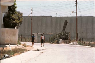
The Wall takes on a variety of forms; around Qalqiliya the Wall is concrete eight meters (25 feet) high and fortified with armed observation posts and in other areas it may be part concrete/part fence or a series of razor wire and/or electric fencing all of which includes a 70-100 meter (approximately 230-330 feet) buffer zone with trenches, roads, razor wire, cameras, and trace paths for footprints. In Bethlehem and Jerusalem, the Wall is made up of a combination of these edifices.
Do you want to add to this site? contact me with your story.afterthewar1@yahoo.com
Related Links
Stop the wall.org - Anti-Apartheid wall campagin
Applied Research Inst. Jerusalem

advertise here!
The Wall is being built deep within the West Bank as it zigzags throughout 10 out of the 11 West Bank districts. The Wall, on this path, annexes nearly 47% of the West Bank and completely destroys all continuity of life in the region.
The Wall begins at the northern most point in the West Bank and runs through the western districts of the West Bank to the north of Jerusalem; the Wall is not being built on or near the 1967 Green Line and at points reaches 16 km (some 10 miles) deep right into the heart of the West Bank in order to annex major Israeli settlements . After cutting through neighborhoods and villages in East Jerusalem, the Wall continues near Bethlehem and continues south towards Hebron. In eastern West Bank, a second wall begins in the northern West Bank and, runs somewhat parallel to the first wall annexes the Jordan Valley, extends south to Jerusalem where it connects with the first Wall, and thereafter stretches through the southern West Bank. (click here for a map)
The cost to build the wall is about $4.7 million per kilometer, a total of $3.4 billion US dollars.
The Buildings:
- Some 218 buildings have been demolished in the village of Nazlat 'Isa, 200 were shops which were in important source of income and survival for a number of communities; five homes have also been demolished for the Wall plus 16 with demolition orders.
- 75 stores, 20 factories, 20 homes, and 1 primary school has demolition orders which are expected to take place in the very near future.